If you have ever flown a plane, you’ve filled a VFR flight plan. Understanding what you need to put on the plan is one thing, and gathering all the data you need is another. With all the information you have rolling around your head it’s easy to forget the simplest of tasks. Here are some of my tips that help me plan my VFR trips and filling out a VFR flight plan.
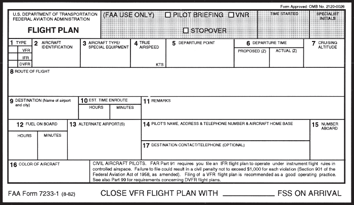
Filling out a VFR flight plan isn’t terribly difficult. Each tip, when it directly relates to a section of the flight plan will reference the block you put that information into.
Check the Weather
Pilots live and breathe weather. If we can’t understand at least the basics of weather than we will have a much harder time flying. There are several resources I use to check weather both as a lead up to my flight date and for flight planning. USAirNet is one of the resources I use as well as 1800wxbrief.com. Knowing the weather is crucial to making a safe flying plan.
Determine the most direct route first
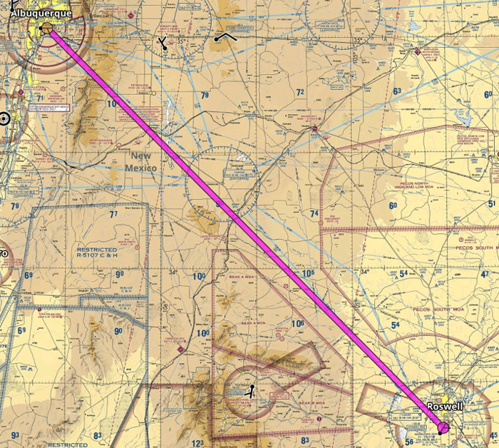
Let’s plan a flight from my home airport of Albuquerque (KABQ) to Roswell (KROW). The straight line route takes me directly over the 10,000′ mountain to the east of Albuquerque. While I won’t fly this direct route it gives me some useful information to see the direct path.
- Distance between the two points (this is great for determining if an airport is far enough to be called a cross country)
- Determine potential obstacles to flight (our next tip)
- Quick look at altitude and terrain along flight path
- First look at the time enroute
You shouldn’t make any quick judgments on a flight before you see the direct route. After all, the shortest distance between two points is a straight line!
For now, my Route of Flight is KABQ direct to KROW
Deviate based on airspace (or terrain)
Once you’ve see whats in your path on the direct route you can change your plan as needed. For example in our sample flight plan I want to divert around the mountain. If you’ve ever tried to fly a 172 at altitude, you would avoid the mountain too!
Bonus Tip: Set your points to a known Airport, Nav or Waypoint to have ATC better understand where you are going.
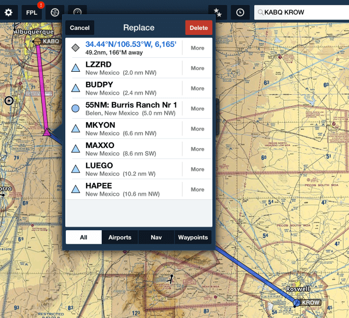
Using Foreflight, or other flight planning software you can drag and drop your route to avoid something on your map. This will then bring up a window showing the nearest known point. If there is a known point within a few miles from your chosen spot pick that one. It will help when you fill out the Route section on the flight plan.
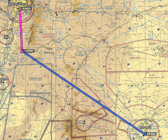
On our sample flight I will go to LZZRD and then down to Roswell. However, the direct path from LZZRD to KROW takes me over Restricted airspace and an MOA (Military Operation Area). I don’t have any intention of being intercepted so I’ll change my flight to head to the Corona VOR and then down to Roswell. Yes, I know that there are times when such airspace isn’t active and I can fly through it, however, I can simply avoid it and not add too much time or distance to my flight.
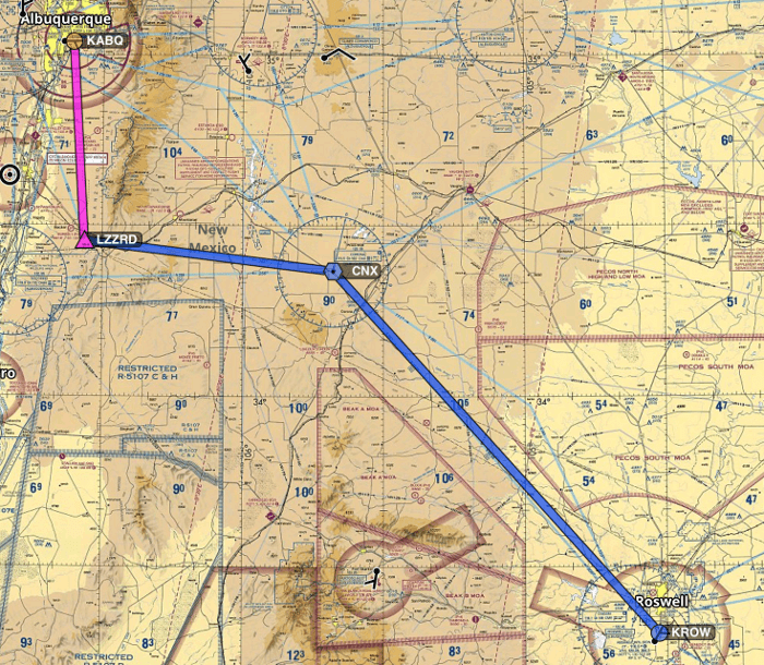
My new Route of Flight (for section 8) is KABQ -> LZZRD -> CNX -> KROW
Check for TFRs
Temporary Flight Restrictions pop up every now and then and for various different reasons. However, breaking a TFR will get you a visit or a phone call from the FAA. Not something I want to willingly do. So, I will check, and avoid, the TFRs.
Where can you find active TFRs? I’m glad you asked. I check foreflight, ask during my weather brief, or check the FAA listing of TFR sites.
As always, a TFR on or near your intended flight path will require a re-route of your intended course. This is easily done the same way I adjusted the sample flight path in the last tip.
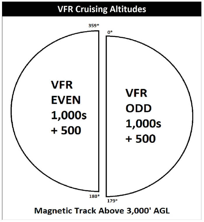
Determine Altitude
My rule of thumb is 2,000 ft AGL minimum, adjusting for VFR altitude rules. As I’m sure you know, 0-179* is odd + 500′ and 180-359* is even + 500′. Below is a handy image to help visualize this.
Now, in the sample flight the first part of our flight is in the 5,000′ ground level and it finishes in the 4,000′ ground level map colors.
Using my rule of thumb I would start my trip out at 7,500′, which I would add to block 7, and I’d likely stay at that altitude for the whole trip, since I’m not sure I want to fly at 5,500 for the last part of my trip. That’s personal preference however, and really no good reason other than being a low time pilot and wanting more time should something go wrong.
Check Winds Aloft
Now that I have the intended route, and my chosen altitude I can check my sources for the winds aloft forecast. Again, this can be done using your favorite flight planning software, any FAA approved weather briefing site or calling 1800wxbrief.
Note, you may find after a quick check of the winds aloft that you have a headwind at the proposed altitude, but higher or lower may give you a tailwind.
An example of this would be if the winds at 7,000′ are our of the south but the winds at 9,000′ are from the north west then I may change my intended altitude to 9,500′ to try and catch the more favorable winds.
Calculate Fuel Consumption
If you are like me, you know on average what your plane’s fuel consumption is. For the 172’s that I fly that’s about 8 gallons an hour. On a short flight, like some pattern work that’s not really going to come into play but for a longer cross country it might. Do you have extended range tanks like one of the planes I fly? Or do you have the regular tanks, like the other one I fly? Which plane did I book for this flight?
These questions are a real struggle for those of us that rent from one operation or another. However, calculating your fuel properly will help you figure out both the minimums to your destination as well as how much fuel to really have onboard. While the old addage is “you never wish for more in the tank”, in my area of the country “you never fly with more fuel than you need”. This helps performance and weight and balance pretty significantly.
Weight and Balance
Speaking of weight and balance, did you actually calculate it? For example, one flight I did had 4 grown men in my 172 in the summer. While I had calculated how much fuel we needed my FBO was reluctant to drain the fuel out of the plane so I could be within W&B. Now, I made that flight, but (as it should have been) the FBO changed their rules to state that the 172 is a 3 pax plane, unless you are carrying children.
It’s very important to do a W&B every time you fly. Especially when you are a new pilot in a plane you are not intimately familiar with. The more you can fly with an understanding of how the plane is centered the better (and safer) your flying will be.
Remember Plane Performance
As well as weight and balance, the performance of the plane is important to consider. Flying at 7 – 10,000 ft in a Cessna 172 is an exercise in flying a plane a bare bones performance. Think for a minute, if you will, what it’s like to climb at 200 – 300 ft / minute. That can be really scary if there is that mythical ’50 foot object’ at the end of the runway.
Not only is climb performance something to take into consideration, but runway distance is important as well. The hotter it is outside, the less performance your plane will have. So, while it may be able to land on the runway, it may not be able to take off.
Now, most of us general aviation pilots don’t ‘usually’ have to worry about it except for extreme cases. However, as you progress in your planes you may have to add runway length to your normal calculations. Especially as you travel to some of the more exotic areas of the world.
Lastly in this category, you will want to consider cruise performance. How fast will your plane fly over the ground. This can and will be affected by not only the ability of the plane to perform but external facts such as wind direction. If you don’t calculate this properly you may not have enough fuel to get you to the destination you were originally planning.
Points of Interest
If you are carrying passengers, you may want to search for points of interest along your route. For example, if you are flying from Albuquerque to San Francisco you may want to point out the Grand Canyon to your visitors as you fly over it.
On a much less grand scale, there are many points of interest for your passengers to look at on any flight. Take the time to show them and they will enjoy the flight that much more.
https://twitter.com/nate_mayyy/status/784198489689522176
Interesting things and landmarks you can point out:
- Canyons
- Caves
- Lakes/Rivers
- Towns
- Local Roads
- “Hey can you see the train from up here?”
- Buildings of note
- Local Landmarks
The more you can point out to your passengers the more enjoyable their flight will be. If they have seen something on the ground, seeing it from the air will make it that much more memorable.
When I last took my sister up in the air I was careful to mention what I was seeing, and what she might recognize during our flight. It helped to keep her engaged while the flight was taking it’s sweet time.
Weather Brief
I’ve mentioned weather before, but now is the time that you add the weather brief to your flight planning routine. The more often you call for a weather brief the better you will get at it. Also, the more likely you are to question what they say.
Let me be clear, if you don’t understand what the briefer is saying you should have them clarify their statement to you. Ask them questions and make the brief about you, not about an FAA statistic.
Really listen to what the briefer says. Don’t put them on hold, or ignore them, or assume that because you called you are safe. There are times when the briefer is the only thing between you and a nasty weather system. Listen to them. Engage with them and you will get the best briefing that both money and experience can buy.
After you have gotten your briefing, make sure you adjust your flight plans, specifically around the time en-route based on what you hear from your briefer.
Flight Planning Software
Doing a VFR flight plan by hand, on paper, is a great exercise. And VERY useful if you are getting ready to take your written. However, there are other ways to file your flight plan. My two favorites are:
- Foreflight
- 1800wxbrief
A caveat for calling 1800wxbrief is you may want to have it written out by hand so you can give the information to the briefer properly. However, the times I call and don’t have anything written in front of me the briefer asks the questions they need to know to properly file the flight plan.
There is other flight planning software out there. While I cannot speak to their ease of use I will list them. Not all of them are for filing your flight plan, but they all have use for the actual PLANNING of your flight and the flight plan. I may decide to try them in the future and provide feedback at that time. In no particular order:
If you have used any of the above, or thing I need to add additional ones let me know in the comments.
Any Plan Can Be Changed
This is the catch all tip. Everything can change in an instant.
Your boss calls and cancels your vacation, the weather is too ugly to fly, you don’t have the money to make the flight like you planned. The fact is you went through the process like you should have. You got the experience you needed on paper.
However, there are times when the plans change in the air. You missed a TFR and flight watch is diverting you. No one predicted the massive thunderstorm building in front of you requiring a deviation from your main course.
In life as in aviation, plans change. The more fluid you are to those changes the better life will end up being for you.
Keep in contact with Flight Following, or update ATC as needed when your plans change. But always remember, you are the pilot in command. Your job is the safety of the flight. It is up to you to make sure you make the best decision with the information on hand. If ATC directs you otherwise, you may tell them no if the safety of your flight is compromised.
What tips do you use when planning your VFR flight? Let me know in the comments.


